Tuesday 14 October 2014

Go Nigeria. See Calabar Festival and Carnival.


Calabar Festival and Carnival, Cross-River, NIGERIA

Let me assume you've heard about or seen the Notting Hill Carnival held annually on the streets of Notting Hill in the Royal Borough of Kensington and Chelsea, London. Let me further assume you know about the annual Rio de Janeiro Carnival in Brasil. These are world class examples of street party in Europe and South America.


Not many know that Africa has its own examples of world class street party the biggest of which is the Calabar Festival and Carnival which holds annually in the south-south Nigerian Cross River State from November 30 through January 1 - a 32-day display of Africa heritage.

Within these 32 days, special attention is given to December 26 and 27. These two days highlight the whole 32-day event with music, dance, drama and visual creativity that is reflected in the design of floats, costumes and makeups. These are the days of Calabar Carnival or Carnival Calabar as it's officially known.

The fun and relaxed atmosphere around the carnival notwithstanding, a great degree of thought, creativity and discipline goes into the interpretation of the carnival theme under a strict adjudication process. The result is pure magic- an outpouring of colour, sound and spectacle, unmatched by anything else on the continent.


The carnival features 5 major competing bands, namely: Bayside Band, Masta Blasta Band, Freedom Carnival Band, Passion-4 Carnival Band and the Seagull Carnival Band; as well as 10 non-competing bands. Each of the major bands is comprised of approximately 10,000 revelers, including up to five kings and queens wearing large scale costumes that interpret the annual theme and set the tone for the other outfits.

Sections of these costumed revelers create a riot of color and sparkle, along a 12km route accompanied by live music, DJs, well-decorated floats and steel bands. The carnival parade terminates at the UJ Esuene Stadium which is the final adjudication and end point of the competition for 'Band of the year' in various categories. This competition attracts an additional 15,000 seated spectators and 10,000 others in and around the stadium, as well as 50 million TV viewers.


Calabar Carnival was created as part of the vision of making the Cross River State in Nigeria, the number one tourist destination for Nigerians and tourist all over the world. The carnival has boosted the cultural mosaic of Nigeria people while entertaining the millions of spectators within and outside the State, and boosting industry for all stakeholders.

Now you've heard about it. Mark your calendar and save the dates for Africa's Biggest Street Party - December 26 - 27, 2014.


Photo Credits: CalabarCarnival.Com, Vanguard Newspapers, Google
Sources: CalabarCarnival.Com, Cross River State Tourism Bureau, Wikipedia

Wednesday 8 October 2014

Visit Zambia, Zimbabwe. See Victoria Falls.


Mosi-oa-Tunya, ZAMBIA and ZIMBABWE

One of the world's most majestic water spectacles is the Mosi-oa-Tunya meaning The Cloud That Thunders. It is otherwise called the Mosikalamosikala meaning The Smoke That Thunders. This legendary waterfall, generally known as the Victoria Falls, is among the biggest, and most awe-inspiring on the planet. Mosi-oa-Tunya was named after the British Queen Victoria when it was discovered by Scotsman David Livingstone in 1855, four years after he heard of the great waterfall.

The Victoria Falls is the largest curtain of falling water in the world; it is 1688 m wide and 108 m high; and with up to 500 million litres per minute descending at 61 m (Devil’s Cataract), 83 m (Main Falls), 99 m (Rainbow Falls), 98 m (Eastern Cataract). It is one of the most amazing sights in the world: twice as tall as Niagara Falls and several times longer. Although not the highest, the widest or the greatest volume of water, they have the largest sheet of water for any fall in the world and are a sight not to be missed.


Victoria Falls is located on the boundary between Zambia and Zimbabwe. It can be seen from Livingstone District of Southern Province of the Republic of Zambia and Hwange District of Matabeleland North Province of Zimbabwe. Two-thirds of the actual falls lie within the Zambian territory. The national border between Zambia and Zimbabwe lies midstream, and national parks of both nations exist on either side of the Zambezi. The gorges and cliffs below the falls in these parks are prime territory for raptors, including taita falcons and black eagles.


The Zambezi River is more than 2 kilometers wide when it cascades over the lip of a large basalt plateau and plunges as much as 354 feet (108 meters). The flow has been slicing slowly through this plateau for some two million years. During this time the river has slowly retreated and the remnants of earlier, ancient falls can be seen in the gorges downstream from the current cataract.

The falls generate mists that can be seen from a distance of 50 km and 30 km from Bulawayo and Lusaka roads respectively. A direct frontage viewing of the falls is possible from both Zambia and Zimbabwe. The mists also sustain a rain forest-like ecosystem adjacent to the falls and on the opposite cliff that faces them like a dried-up mirror image, thick with mahogany, fig, palm, and other species of vegetation.


The falls are massive and invite contemplation from many different viewpoints. You can walk around the area and enjoy the vistas. Unique views are also to be had from the Knife Edge Bridge and Victoria Falls Bridge. River-level views from below the falls are a good way to experience their power up-close. At certain times of the year the daring may even swim in pools on the very crest of the cataract.

The river is typically in full flood during February and March, when as much as 540 million cubic meters of water fall over the edge every single minute. During the rainy season, however, the spray plume can obscure the view of the falls themselves. By November, when the water is at low ebb, visitors may see the curtain split into many smaller channels of falling water.

The big question is which side to visit Victoria Falls: Zambia or Zimbabwe? A decision will be made after considering views of the falls and cost.


The water from Victoria Falls dives into a narrow gorge running parallel to the face of the falls, with the spray going high into the air, causing permanent rain, rainbows and the famous "smoke" which is visible from a distance, so, much of the time when you are viewing the falls, you are actually facing them. The gorge where the water exits is the limit on how far you can walk from either side. There is no crossing there. This limits your visibility from the Zambian side, as you can walk about only a quarter of the distance of the face of the falls. Although the view and the waterflow is still impressive, you simply cannot get a perspective on the full width of the falls from the Zambian side.

The walk down to below the falls is closed on the Zimbabwean side. You can only walk down on the Zambian side. The footbridge on the Zambian side gives a unique experience, with a permanent torrential rain from the wet season through to August.

To cross the border from Zambia to see the falls on the Zimbabwe side, you will need to pay at least US$30 for a Zimbabwe single entry visa depending on your nationality. And, if you want to return to the Zambian side, you will need to pay an extra US$20 for a multiple entry Zambian visa. To cross the border from the Zimbabwean side to the Zambian side you will need to pay at least US$20 for a single day Zambian visa, and at least an extra US$15 for a multiple entry Zimbabwean visa.


You will need to decide whether you are getting a single or multiple entry visa when you first apply for it. If you are flying from South Africa just to see the falls, consider if it is worthwhile arriving on the Zimbabwean side and leaving from the Zambian, as you will minimize your visa costs this way but may pay more for airfares. Flying to the Zambian side usually costs less than flying into the Zimbabwe side.


Photo Credits: FamousWonders.Com, CNN Travel, World-Visits Blog, Google, Zambia Tourism
Sources: CNN Travel, National Geographic, Zambia Tourism, UNESCO, Wikitravel

Go Botswana. See Makgadikgadi Pans.


Makgadikgadi Pans, Tutume, BOTSWANA

Will you ever imagine an area the size of Portugal largely uninhabited by humans? Okay! There's one with a stark, flat, featureless terrain which seems stretches to eternity, meeting and fusing with a milky-blue horizon. This is the Makgadikgadi, an area of 12000 sq kms, part of the Kalahari Desert, one of the largest salt pans in the world. It's said you can hear your own blood flow in this vast area of dried-up salt pans, a landscape formed by a huge lake that dried up millennia ago.

Makgadikgadi, the name which implies a vast open lifeless land, is not without its folklore. There are stories of people setting out from Gweta to explore the land that lay between them and the Boteti River to seek a favourable environment in which to settle. They entered these great thirstlands at the driest time of year, drawn by what they perceived as large lakes of sparkling water on the horizon. Suffering badly from thirst, the lakes kept drawing them hurriedly on in their attempts to reach the life-giving water that always remained just ahead of them. Gradually, one by one, they fell and died. This is a sobering thought, but quite understandable when personally witnessing these mirages.


For much of the year, most of this desolate area remains waterless and extremely arid; and large mammals are thus absent. But during and following years of good rain, the two largest pans - Sowa to the east and Ntwetwe to the west - flood, attracting zebra and wildebeest on the grassy plains; and most spectacularly flamingos at Sowa and Nata Sanctuary. Flamingo numbers can run into the tens of thousands and sometimes hundreds of thousands, and the spectacle can be completely overwhelming. It is unfortunate that this huge water spectacle becomes practically inaccessible by road at this time, but anyone fortunate enough to fly over the area during the wet season surely sees a water wonderland of incredible scenic beauty.


The rainwater that pours down on the pans is supplemented by seasonal river flows from the Nata, Tutume, Semowane and Mosetse Rivers in the east, and in years of exceptional rains, the Okavango via the Boteti River in the west. During this time, the pans can be transformed into a powder blue lake, the waters gently lapping the shorelines, and flowing over the pebble beaches; a clear indication of the gigantic, prehistoric lake the Makgadikgadi once was.


The Makgadikgadi is in fact a series of pans, the largest of which are Sowa and Ntwetwe, both of which are surrounded by a myriad of smaller pans. North of these two pans are Kudiakam pan, Nxai Pan and Kaucaca Pan. Interspersed between the pans are sand dunes, rocky islands and peninsulas, and desert terrain. No vegetation can grow on the salty surface of the pans, but the fringes are covered with grasslands. Massive baobab trees populate some fringe areas and their silhouettes create dramatic landscapes against a setting sun.

The lesser known Makgadikgadi Pans National Park is situated roughly halfway between Maun and Nata on the road between these two villages in northern Botswana. A modest looking turnoff to the park's main entrance can be found 160 km east of Maun and 45 km west of the small village of Gweta, which has the nearest lodge accommodation, fuel and supplies.


The Makgadikgadi Pans National Park is situated on State Land. People have never been resident in its waterless interior, but in times of drought, surrounding villagers were permitted to graze their livestock within the area, withdrawing them to their homes when conditions improved. The area was declared a game reserve in 1970; and in December 1992, the boundaries were extended and National Park status was attained. The present park covers some 4900 sq km.


In the wet season, this reserve can offer good wildlife viewing, particularly when large herds of zebra and wildebeest begin their westward migration to the Boteti region. other species include gemsbok, eland and red hartebeest, as well as kudu, bushbuck, duiker, giraffe, springbok, steenbok, and even elephant, with all the accompanying predators, as well as the rare brown hyena.


From turning off the main tar road, 8 km of rough gravel road leads to the park entrance gate, where entry fees are to be paid. All roads within the park are rough and in many cases very sandy, so it is essential to have a 4x4 vehicle. It is also wise to carry water and travel in tandem with a second vehicle, as, if there should be a breakdown deep within the park, it may be a long wait before any other vehicle is likely to come along to assist.

Here, as with all parks and reserves, the use of an anti-malarial prophylactic is strongly recommended and, when travelling within these areas, a 4x4 vehicle, carrying emergency water and food, is necessary. Engaging 4-wheel drive before negotiating sandy patches not only minimises the possibility of becoming stuck, but also saves chewing up the road surfaces for others.


Both dry season and wet season visits to this park are recommended in order to witness the dramatic appearance of the pans at their driest, to experience the transformation to a water wonderland and see the wildebeest and zebra migrations, in the wet season. Linking a few days in Makgadikgadi with a similar period of time in its nearby sister park, Nxai Pan, will give visitors a distinctly different experience. Makgadikgadi - a vast wilderness of space and timelessness.


Photo Credits: Botswana Tourism Board, Kingfishersafari Blog, Leisurewheels SA, CNN Travel
Sources: Botswana Tourism Board, Makgadikgadi National Park, CNN Travel, TripAdvisor

Visit DR Congo. Climb Nyiragongo Volcano.


Virunga National Park, Virunga, DEMOCRATIC REPUBLIC OF CONGO

The 7800 square kilometer Virunga National Park is the oldest national park in Africa and the second oldest in the world (after Yellowstone). The park, UNESCO World Heritage Site, lies on the eastern border of the Democratic Republic of Congo, where it borders Uganda as well as Rwanda. It derived its name from the Virunga Mountain (volcanoes) range that lie in the south of the park.

Virunga National Park comprises an outstanding diversity of habitats, ranging from swamps and steppes to the snowfields of Rwenzori at an altitude of over 5,000 m, and from lava plains to the savannahs on the slopes of volcanoes. The park however is much larger and stretches all the way north to envelop Lake Edward as well as the Rwenzori Mountains. Mountain gorillas are found in the park. Some 20,000 hippopotamuses live in the rivers and birds from Siberia spend the winter there.

The nightly glow from the lava lake within the Nyiragongo volcano can be seen from miles away. Virunga National Park is unrivalled in its diversity of landscapes and ecosystems. The parks boundaries envelop low land tropical forest in the north; high alpine forest in the Rwenzori Mountains; riverine forest around the Semliki and Rutshuru rivers; swamplands around Lake Edward, savannah north and south of the lake; montane forest on the hills of the Virunga volcanoes and old (and new) lava flow landscapes.


The Nyiragongo Volcano is famous for its lava lake which is the largest in the world. Climbing the volcano is a technically easy task from the direction of Goma. A trip to the top should take less than 6 hours. Most climbers stay overnight and sleep on the summit in the Nyiragongo Crater Cabanes with a view over the largest lava lake in the world. This also makes it possible to see the boiling lava by night, when it becomes even brighter. Nyiragongo Volcano Trek Permit is about $200.

Apart from climbing the volcano and seeing the mountain gorillas, tourists also visit the Tongo ChimpsVirunga National Park has a habituated Chimpanzee group in the picturesque hills of Tongo, located in the southern sector of Virunga National Park. Tongo is a unique forest island and home to a small population of chimpanzees at the west of Rumangabo, the park headquarters. The forest lies on one of the lava flows from Nyamulagira Volcano.


Tourists to the Virunga National Park can obtain a Rwenzori Mountain Trek Permit for around $200. The Rwenzori Mountains are a snow capped mountain range in the north of Virunga National Park on the border with Uganda. The highest peak in the range lies on the border and can be climbed from both countries. The trek to the glacier can be made in a 4-5 or 6 day trek. To start the trek visitors will need to travel to Beni by flight from either Goma or Entebbe.

Tourists wishing to see the mountain gorillas can access the Mikeno Sector of Virunga National Park in a number of different ways. To see the mountain gorilla sites at Jomba and Bikenge, tourists can come in overland through Uganda by crossing the Bunagana border which is about 1 hour drive to the sites. With a local visa which can be bought for $50 at the border, the border crossing gives no hassles. However, this visa is not a fully recognized visa and can only be used to visit the park and subsequently leaving the country at the Bunagana border post again. The permit to see the Mountain Gorillas is $400.


Also, with a pre-arranged visa, tourists can come into the DRC overland through Rwanda by crossing the Gisenyi/Goma border. Unlike crossing the Bunagana border via Uganda, crossing Gisenyi/Goma border without a pre-arranged visa will be difficult or expensive. Visas purchased at the border crossing cost around $280. Alternatively, with a pre-arranged visa, tourists can fly into Goma. Many flights from within the DRC connect to Goma but a flight to Entebbe is necessary if flying in from outside the DRC.


Photo Credits: Virunga National Park, CNN Travel, Wikipedia, Google
Sources: UNESCO, Wikitravel, Virunga National Park, VisitVirunga.Org

Go Nigeria. Climb Olumo Rock.


Olumo Rock, Abeokuta, NIGERIA

There is no way the history of Abeokuta, an ancient city in southwestern Nigeria, will be told without the mention of Olumo Rock. Why? you'll want to ask. Read on to find out the role and importance of Olumo Rock to the Egba people who are the inhabitants of Abeokuta.

Olumo Rock is one of the most popular tourist destinations in Nigeria. The rock sits in the city center of Abeokuta (meaning Under the Rock) which was originally inhabited by the Egba people who found refuge at the Olumo Rock during the inter-tribal wars of the 19th century. The rock provided sanctuary to the Egba people as well as a vantage point to monitor the enemy's advance leading to eventual victories in war. Abeokuta eventually grew as new settlers spread out from this location.

Abeokuta is just a 1-hour drive from the nation's commercial capital, Lagos. Thus, providing convenient access to an array of first-class hotels, restaurants, clubs, casinos and various nightlife activities. Lagos is also home to the country's aviation hub, the Murtala Muhammed International Airport which is the closest airport to Abeokuta. Among numerous hotels within minutes of driving from the Olumo Rock are the state-owned Gateway Hotel, Dusmar Presidential Hotel, Crown Royal Hotel, Swiss International Hotel, Continental Suites, Daktad Hotel, and Supreme Hotel among others.


Tourists to Africa definitely need to consider putting a visit to Olumo Rock on their travel plans. Infrastructures at the Olumo Rock were upgraded in 2006 after the massive renovation of the tourist site. The site now has a new museum, restaurants, water fountain and an elevator that makes the climbing challenge an easy task.
  
The ancient Itoku market where local artisans and traders enjoy to haggle over the price as much as the customers like to find a bargain lies just outside the Olumo Rock premises and is a must-see. The Itoku market is the center of the indigenous Abeokuta industry of tie-and-dye, locally known as Adire. Apart from the adire, other popular items to watch out for include local beads, bracelets, sculptures and musical instruments like the Sekere and Gangan (the talking drum).


A trip to Olumo Rock usually starts with a climb up the man-made stairs carved into the rock. While this sounds easy enough, it leaves many breathless and ready to take a break to rest on the benches under the trees growing from the rock and enjoy some fresh and clean breeze. The journey continues with climbs on irregularly sized rocks through a narrow corridor that leads to the top of the rock. All along the way, catch sights of carvings in the rock, cowrie-studded statues and the ancient abode of the priestesses who live in huts on the rock. And yes, it is not uncommon to catch a sight of the very aged women who live there and mutter greetings or blessings as people make their way through.

It is often helpful to enlist the services of a guide who possesses vast knowledge of the history of the rock and the culture of the people. This makes for an interesting climb as every twist and turn will reveal a significant story making the visit a truly memorable one.


On the way down the rock, the sight of the Ogun River (the river from which the State - Ogun State - derived its name) running like a silver chain amidst a forest of aged red corrugated roofs bordered by thick green forests which melt into the horizon is breathtaking.

Photo Credits: Dossy Blog, OlumoRock.Com, Google
Sources: OlumoRock.Com, Wikipedia, The Punch Newspaper

Monday 6 October 2014

Visit Egypt. See the Pyramids of Giza.


The Great Pyramids, Giza, EGYPT

Egypt, officially, the Arab Republic of Egypt, is in north-eastern Africa with its capital located in its largest city, Cairo. Egypt also extends into Asia by virtue of holding the Sinai Peninsula. Egypt is bordered by Israel and the Gaza Strip to the north-east, by Sudan to the south and by Libya to the west. The country is bounded by the Mediterranean and Red Seas (to the north and east respectively) and geographically dominated both by the Nile River and its fertile well-watered valley, and by the Eastern and Western deserts.

Tourism is Egypt’s second largest source of revenue, bringing in $13 billion in 2010. To visit the Pyramids is to be struck dumb by their monumentality, their celebration of the fundamental human need to create. It's even more affecting in the midst of a revolution, when there are no tourists at all. A week after Hosni Mubarak's departure and a day after the biggest celebration in Tahrir Square, a handful of Egyptians scrambled up the blocks of Khufu's Great Pyramid, but there was not a foreigner to be seen.

                                          
Giza Necropolis
The Giza Necropolis, otherwise known as the Pyramids of Giza is an archaeological site on the Giza Plateau, on the outskirts of Cairo, Egypt. This complex of ancient monuments includes the three pyramid complexes known as the Great Pyramids, the massive sculpture known as the Great Sphinx, several cemeteries, a workers' village and an industrial complex. It is located some 9 km (5 mi) inland into the desert from the old town of Giza on the Nile, some 25 km (15 mi) southwest of Cairo city centre. The pyramids, which have always loomed large as emblems of ancient Egypt in the Western imagination, were popularised in Hellenistic times, when the Great Pyramid was listed by Antipater of Sidon as one of the Seven Wonders of the World. It is by far the oldest of the ancient Wonders and the only one still in existence.

The Pyramids of Giza consist of the Great Pyramid of Giza (known as the Great Pyramid and the Pyramid of Cheops or Khufu), the somewhat smaller Pyramid of Khafre (or Chephren) a few hundred meters to the south-west, and the relatively modest-sized Pyramid of Menkaure (or Mykerinos) a few hundred meters further south-west. The Great Sphinx lies on the east side of the complex. Current consensus among Egyptologists is that the head of the Great Sphinx is that of Khafre. Along with these major monuments are a number of smaller satellite edifices, known as "queens" pyramids, causeways and valley pyramids.

Great Pyramid of Giza
The Great Pyramid of Giza is the oldest and largest of the three pyramids in the Giza Necropolis bordering what is now El Giza, Egypt. It is the oldest of the Seven Wonders of the Ancient World, and the only one to remain largely intact. Egyptologists believe that the pyramid was built as a tomb for fourth dynasty Egyptian Pharaoh Khufu (Cheops in Greek) over a 10 to 20-year period concluding around 2560 BCE. Initially at 146.5 metres (481 feet), the Great Pyramid was the tallest man-made structure in the world for over 3,800 years. Originally, the Great Pyramid was covered by casing stones that formed a smooth outer surface; what is seen today is the underlying core structure. Some of the casing stones that once covered the structure can still be seen around the base. There have been varying scientific and alternative theories about the Great Pyramid's construction techniques. Most accepted construction hypotheses are based on the idea that it was built by moving huge stones from a quarry and dragging and lifting them into place.


Khufu (Cheops) Pyramid
There are three known chambers inside the Great Pyramid. The lowest chamber is cut into the bedrock upon which the pyramid was built and was unfinished. The so-called Queen's Chamber and King's Chamber are higher up within the pyramid structure. The Great Pyramid of Giza is the only pyramid in Egypt known to contain both ascending and descending passages. The main part of the Giza complex is a setting of buildings that included two mortuary temples in honor of Khufu (one close to the pyramid and one near the Nile), three smaller pyramids for Khufu's wives, an even smaller "satellite" pyramid, a raised causeway connecting the two temples, and small mastaba tombs surrounding the pyramid for nobles.


Khufu’s pyramid complex consists of a Valley Temple, now buried beneath the village of Nazlet el-Samman; basalt paving and nummulitic limestone walls have been found but the site has not been excavated. The Valley Temple was connected to a causeway which was largely destroyed when the village was constructed. The Causeway led to the Mortuary Temple of Khufu. From this temple only the basalt pavement remains. The mortuary temple was connected to the king’s pyramid. The king’s pyramid has three smaller queen’s pyramids associated with it and five boat pits. The boat pits contain a ship, and the two pits on the south side of the pyramid still contained intact ships. One of these ships has been restored and is on display. Khufu's Pyramid maintains a limited collection of casing stones at its base. These casing stones were made of fine white limestone quarried from the nearby range.

Khafre (Chephren) Pyramid
Khafre's pyramid complex consists of a Valley temple (sometimes referred to as the Sphinx temple), a causeway, a mortuary temple and the king’s pyramid. The Valley Temple yielded several statues of Khafre. Several were found in a well in the floor of the temple by Mariette in 1860. Others were found during successive excavations by Sieglin (1909-10), Junker, Reisner, and Hassan. Khafre’s complex contained five boat-pits and a subsidiary pyramid with a serdab. Khafre's Pyramid appears larger than the adjacent Khufu Pyramid by virtue of its more elevated location, and the steeper angle of inclination of its construction - it is, in fact, smaller in both height and volume. Khafre's Pyramid retains a prominent display of casing stones at its apex.


Menkaure (Mykerinos) Pyramid
Menkaure's pyramid complex consists of a Valley Temple, a causeway, a mortuary temple, and the king’s pyramid. The Valley Temple contained several statues of Menkaure. During the 5th dynasty, a smaller ante-temple was added on to the Valley temple. The Mortuary temple also yielded several statues of Menkaure. The king’s pyramid has three subsidiary or Queen’s pyramids. Of the four major monuments, only Menkaure's Pyramid is seen today without any of its original polished limestone casing.

                                                 
The Sphinx
The Sphinx dates to the reign of King Khafre. A chapel was located between its forepaws that had unfortunate history of being repeatedly destroyed by unusual circumstances. During the New Kingdom, Amenhotep II dedicated a new temple to Hauron-Haremakhet and this structure was added onto by later rulers.


Visitors to the pyramids will need a passport for this trip. First time applicants will pay $100 per adult and $85 per child under age 16. Thirty-day tourist visas are available at Egypt airports for $15. Packing for Cairo may send would-be travelers shopping. In addition to the hot-weather vacation standards of a hat, comfy shoes and sunglasses, female travelers will need to pay extra attention to their wardrobe. Egyptian tourism officials advise women to conform to the local views of modesty by avoiding shorts and low-cut shirts. They suggest wearing loose-fitting clothes with long sleeves


The best time to visit Egypt weather-wise is from September to November. Bargain hunters can find better airline and hotel rates from June to August, but they’ll also probably encounter 113-degree days. In March and April, high winds may kick up sand and affect visibility.


Photo Credits: National Geographic Channel, Google, GotoEgypt.Org
Sources: Wikitravel, What It Costs, National Geographic Channel, CNN Travel, Wikipedia

Go Kenya. See Maasai Mara National Reserve.


Maasai Mara, KENYA

The Maasai people of East Africa live in southern Kenya and northern Tanzania along the Great Rift Valley on semi-arid and arid lands. The Maasai occupy a total land area of 160,000 square kilometers with a population of approximately half a million people. However, many Maasai see the national census as government meddling and often miscount their numbers to census takers.


Maasai Mara National Reserve
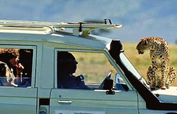
The Maasai Mara is one of the best known and most popular reserves in the whole of Africa. At times and in certain places it can get a little overrun with tourist minibuses, but there is something so special about it that it tempts you back time and again.

Seasoned safari travelers, travel writers, documentary makers and researchers often admit that the Masai Mara is one of their favourite places. This, perhaps, is because of the 'big skies', the open savannahs, the romance of films like Out of Africa and certainly because of the annual wildebeest migration, the density of game, the variety of birdlife and the chance of a hot air balloon ride.

Also because of the tall red-robed Maasai people whose lifestyle is completely at odds with western practices, and from whom one learns to question certain western values. A combination of all these things plus something to do with the spirit of the place - which is hard to put into words - is what attracts people to the Mara over and over.


The Maasai Mara lies in the Great Rift Valley, which is a fault line some 3,500 miles (5,600km) long, from Ethiopia's Red Sea through Kenya, Tanzania, Malawi and into Mozambique. Here the valley is wide and a towering escarpment can be seen in the hazy distance. Most of the game viewing activities occur on the valley floor, but some lodges conduct walking tours outside the park boundaries in the hills of the Oloololo Escarpment. The animals are also at liberty to move outside the park into huge areas known as 'dispersal areas'. There can be as much wildlife roaming outside the park as inside. Many Maasai villages are located in the 'dispersal areas' and they have, over centuries, developed a synergetic relationship with the wildlife.


There are four main types of topography in the Mara: Ngama Hills to the east with sandy soil and leafy bushes liked by black rhino; Oloololo Escarpment forming the western boundary and rising to a magnificent plateau; Mara Triangle bordering the Mara River with lush grassland and acacia woodlands supporting masses of game especially migrating wildebeest; Central Plains forming the largest part of the reserve, with scattered bushes and boulders on rolling grasslands favoured by the plains game.


There are two major seasons in the Mara: the rainy season and the dry season. It rains in April and May and again November and this can cause some areas of the Mara to be inaccessible due to the sticky 'black cotton' mud. The dry season is from July to October when the grass is long and lush after the rains. This is a good time to come and see the huge herds of migratory herbivores.

The Maasai Mara climate  is somewhat milder and damper than other regions because of its high altitude: 4,875 - 7,052 feet (1,500 - 2,170 metres) above sea level. The tempearture rarely exceeds 85°F (30°C) during the day and hardly ever drops below 60°F (15°C) at night. Tourists looking forward to a summer-like weather will visit in December and January because both months are the warmest time of the year. However, June and July are the coldest months in the Mara.


As a matter of fact, tourists to Maasai Mara will be happy to partake in any of its specialties viz: 

  • Wildebeest Migration
  • Hot Air Ballooning
  • Huge savannahs of golden grasslands
  • Big skies
  • Rift Valley escarpment
  • Lion sightings

Photo Credits: Maasai Association, Journey Mart, Google
Sources: Game-Reserve.Com, MaasaiMara.Com, Maasai Association, Journey Mart, Wikitravel

Visit Swaziland. Attend the Reed Dance Festival.


The Uhmlanga Festival, Ludzidzini, SWAZILAND

Umhlanga was created in the 1940s in Swaziland under the rule of King Sobhuza II as an adaptation of the umcwasho ceremony which was an older cultural practice in the Swazi Kingdom.

Umhlanga, or the Reed Dance ceremony, is an eight-day ceremony held annually in Swaziland and by the Zulu in South Africa. The cultural event sees young girls cut reeds and present them to the Queen Mother (Indlovukazi) to repair the windbreak around her royal residence; and then dance in celebration. Up to 60,000 unmarried Swazi girls and women travel from the various chiefdoms to Ludzidzini to take part in the eight-day event making it one of the biggest and most spectacular cultural events in Africa. Taking place over a week, it is largely private, however its final two days are open to the public.


The eight-day event kicks off with a gathering of the girls at the Queen Mother's royal village at Ludzidzini (it used to be Lobamba during Sobhuza's reign). They come in groups from about 200 chiefdoms. The girls are supervised by about four men who appoint  chiefs or group leaders for them. This is a very exciting time for the maidens as they pass the night in the huts of relatives in the village or in classrooms of nearby schools.

On the second day, the girls are grouped into two using their age brackets: the older group consists of girls between age 14 to 22 years and the younger group is made of girls of age 8 to 13 years. This is done to determine how far each girl will trek. In the afternoon, they march to the reed-beds with their supervisors. The older girls often march about 30 km, while the younger girls march about 10 km.


The girls cut their reeds, usually about ten to twenty, using long knives. This happens on the third day. Each girl ties her reeds into a bundle. Nowadays they use strips of plastic for the tying, but those mindful of tradition will still cut grass and plaint it into rope. However, in the afternoon of the fourth day, the girls set off to return to the Queen Mother's village, carrying their bundles of reeds. Again they return at night to show they traveled a long way.


Before the proper festivities kick off on day six when dancing gets under way in the afternoon, the girls observe the fifth day as a day of rest where they make final preparations to their hair and dancing costumes. Day 6 is the first day of dancing. After dropping their reeds outside the Queen Mother's quarters the girls move to the arena and dance, keeping their groups and each group singing different songs at the same time. 


The second and last day of dancing is the seventh day when His Majesty the King honors the girls with his presence. The event comes to a close on the eighth day after the girls have received pieces of meat.

Little can prepare you for the sheer scale of the pageantry, with column upon column of girls advancing like vast ululating centipedes across the parade grounds of Ludzidzini, each dissolving in turn into the pulsating mass of bodies around the royal kraal. 
Today the Umhlanga is as well attended as ever. Indeed cultural historians marvel at how its ever-increasing popularity in Swaziland defies the apparent decline of traditional culture elsewhere. It offers visitors a unique experience. 

The event takes place around the last week of August or first week of September. The dates for the event are released relatively close to the time as they derive from ancestral astrology.


Tourists visiting the annual Reed Dance are not permitted to take photographs. Officially, permits are required for photography. If you are taking photographs for media organisation then please follow the rules.


Photo Credits: The Sydney Morning Herald, Google, Swaziland Tourism
Sources: The Kingdom of Swaziland, Wikipedia, The Sydney Morning Herald


Go South Africa. See the Table Mountain.


 Table Mountain, Cape Town, SOUTH AFRICA

Table Mountain is a South African icon and the only natural site on the planet to have a constellation of stars named after it - Mensa, meaning the tableTable Mountain is a flat-topped mountain forming a prominent landmark overlooking the city of Cape Town in South Africa. It is a significant tourist attraction, with many visitors using the cableway or hiking to the top. The mountain forms part of the Table Mountain National Park. The flat-topped mountain has withstood six million years of erosion and hosts the richest, yet smallest floral kingdom on earth with over 1,470 floral species. Table Mountain boasts numerous rare and endangered species. It is the most recognized site in Cape Town, the gateway to Africa, owing to its unique flat-topped peaks which reach 1,086m above sea level.


The iconic Table Mountain which is one of the 7Wonders of Nature looms large whether you are arriving by plane, train, boat or automobile. Looking at it from below is one thing, but it is quite another to be atop the mountain, from where one is afforded such wonderful views of Cape Town, Robben Island, the Peninsula and beyond.

The main feature of Table Mountain is the level plateau approximately 3 kilometres (2 mi) from side to side, edged by impressive cliffs. The plateau, flanked by Devil's Peak to the east and by Lion's Head to the west, forms a dramatic backdrop to Cape Town. This broad sweep of mountainous heights, together with Signal Hill, forms the natural amphitheatre of the City Bowl and Table Bay harbour. The highest point on Table Mountain is towards the eastern end of the plateau and is marked by Maclear's Beacon, a stone cairn built in 1865 by Sir Thomas Maclear for trigonometrical survey. It is 1,086 metres (3,563 ft) above sea level, about 19 metres (62 ft) higher than the cable station at the western end of the plateau.


One can of course walk up Table Mountain, but getting to the top of Cape Town's mountain doesn't have to involve any more exertion than stepping aboard the 85-year-old  Table Mountain Cableway which provides one with a gentle, quick and vista-full trip up to the top of the mountain. Please note that the cableway is a weather-dependent operation and strong winds and poor visibility on top of the mountain will result in a suspension of services or closing of the cableway. You may have to contact the Table Mountain Cableway to confirm that the car is operational on your chosen day.


The trip to the top is an outing in itself, as you are safely and gently transported from the lower cable station to the top of the mountain and vice-versa.  The journey takes a little more than 5 minutes and the high tech rotating cable car offers the best views of the city.  There are trips up and down every 10 - 15 minutes and the cableway operates 7 days a week, with the first car heading up at 8h00.  The departure time of the last car down depends on the time of the year, and varies between 18h30 and 21h30.  Click here for updated operating times.  Once at the top, over 3500ft above the city, you will find a vast network of well-marked paths to explore as well as strategically positioned lookout points.


There is a restaurant atop the mountain offering full meals as well as a small shop where you can pick up a snack and a post card.  One could also pack a tasty picnic to enjoy at the top, remembering of course that you will be in the Table Mountain National Park, so please make use of refuse bins, or better still take all your waste down with you.

Visitors to Table Mountain can enjoy wonderful views of the (Dassie) scuttling along the rocks, lizards sunning themselves, butterflies flitting past and you might even be lucky enough to spot a porcupine digging for bulbs. The bird life is wonderful too, from the large Verreaux Eagles to the small colourful sunbirds.  One of the beautiful species of protea, the national flower of South Africa, that can be found on the mountain. All these creatures live in the fynbos, and 100's of these plant species occur no where else on the planet.


Table Mountain is at the northern end of a sandstone mountain range that forms the spine of the Cape Peninsula. To the south of the main plateau is a lower part of the range called the Back Table. On the Atlantic coast of the peninsula, the range is known as the Twelve Apostles. The range continues southwards to Cape Point.

Table Mountain makes Cape Town, one of the world's best beach cities, also one of the world's most photogenic.


Photo Credits: New7Wonders, TableMountain.Net, Google, South African Tourism
Sources: TripAdvisor, Wikipedia, Cape Town Tourism, New7Wonders, CNN Travel

Visit Nigeria. See Yankari National Park.


Yankari Game Reserve, Bauchi, NIGERIA

Yankari Game Reserve is located about 225km east of the Nigerian city of Jos and it covers an area of 2,244 sq km. Yankari Game Reserve has been described by the Lonely Planet Guide as holding about the only remnant of wildlife left in Nigeria.


Yankari National Park is a large wildlife park and is home to several natural warm water springs, as well as a wide variety of flora and fauna. Its location in the heartland of the West African savanna makes it a unique way for tourists and holidaymakers to watch wildlife in its natural habitat. Yankari was originally created as a game reserve in 1956, but later designated Nigeria’s biggest national park in 1991. It is the most popular destination for tourists in Nigeria and, as such, plays a crucial role in the development and promotion of tourism and ecotourism in Nigeria. It is also one of the most popular eco-destinations in West Africa.

The Wikki Warm Springs is another attraction to visitors. It is located near the park lodge and is about 200m long and 10m wide, containing crystal-clear water at a temperature of around 31 degrees Celsius.

With about 550 elephants, this park has the largest elephant population in West Africa. However, sighting the animals is not so easy, as the vegetation in the area is quite dense. The best time to view the animals is late February to late April.

Baboons and elephants often come down to the springs. Accommodation is available at a hotel at the warm springs. The other option is to stay in Bauchi, 117 km northwest of Yankari. Camping facilities are also available.


The park also has over 130 wells, all of which have interconnecting shafts sank. This settlement and the wells were once used as a resting place by the trans atlantic slave traders of the early times.

The park also has more than 59 caves located some 7km north east of Wikki camp. Other attractions are the hills, such as Kalban Hill – a flat top hill that gives tourists the opportunity to have a complete view of the park. Kanyo Hill provides a good view of the park and serves as a very beautiful picnic ground. Paliyaram Hill is a popular camp for poachers.


The Yankari Game Reserve covers about 2240 square kilometres of land, and is supervised by a team of rangers to protect the land and its wildlife. Unfortunately, even with the diligent efforts of the rangers to maintain the animal population, there is still the threat from poachers who have a hand in the illegal ivory trade. 

Along with the elephants, which are one of the reserves most popular attractions, you can see some of these other creatures in their natural habitat:
  • Baboons
  • Hippos
  • Buffalo
  • Lions
  • Hartebeest
  • Roan

Sometimes, seeing the animals is difficult as they have mastered the art of remaining camouflaged within the dense vegetation, but if you perch down near a watering hole, they will eventually come. 

Of course, each reserve comes with its own set of regulations, so make sure you're well versed on your do's and don'ts before leaving the ranger station.


Photo Credits: Nigerian Tourism Development Board, Yankari National Park, Google
Sources: Nigeria Tourism Development Board, Wikipedia, NorthSouthTravel